
What is a drone pipeline inspection?
It is a flight by a drone along the route of a pipeline, with a camera pointed at the ground, to record the surface of the strip the line runs under. The pictures are read for anything that was not there before and anything that should not be there at all.
Right-of-way. The strip of land along a pipeline. The rules speak of the surface conditions on it and adjacent to it 1.
Patrol. A regular look along the right-of-way. The United States gas rule calls for a patrol programme to observe surface conditions for indications of leaks, construction activity and other factors affecting safety and operation 2.
Chainage. The distance along the line from a fixed starting point. A finding given by chainage can be found again by anyone with the alignment sheet.
Excavation damage. Damage done to a buried line by digging. The United States pipeline safety regulator calls it a leading cause of life-threatening pipeline incidents, and a preventable one 3.
What does a drone look for along a pipeline?
One row per finding that a rule or a regulator names, in the sources we have read. India's standards for natural gas pipelines lead where they name a finding 5; the United States sources are documented examples from another country.
| The finding | What it looks like | Which camera shows it | Why it matters |
|---|---|---|---|
| The finding: Construction activity on or beside the strip | Fresh earth, stacked material, machinery, a new foundation. | Colour | India's patrol clause names construction activity among the things a patrol is there to observe 5, and so does the United States gas rule 2. |
| The finding: An encroachment on the strip | A wall, a shed, a fence or a stack of material where the strip was clear on the last flight. | Colour | India's patrol clause names encroachments among the things a patrol is there to observe 5. |
| The finding: An excavator or other machine on the strip | A machine where there was none on the last flight. | Colour | Excavation damage is a leading cause of life-threatening pipeline incidents, and it can be prevented 3. |
| The finding: Fresh digging or a trench | Disturbed ground, or a cut across the strip. | Colour | The same: digging is how a buried line gets hit 3. |
| The finding: Signs of a leak on the surface | Whatever the operator's own procedure lists as an indication. The rule asks for indications of leaks to be observed and does not list them. | Colour | It is the first thing the United States gas rule names for a patrol 2, and India's patrol clause names leakage 5. A camera does not detect a leak; see “What this is not”. |
| The finding: A change in the surface itself | Ground that has washed out, slipped or eroded since the last flight. | Colour | India's patrol clause names soil wash-outs 5. The United States rules ask for the surface conditions on and beside the right-of-way to be inspected and do not list them 12. |
| The finding: Exposed pipe or debris at a water crossing | A stream bed scoured down to the pipe, or debris piled against a crossing, after heavy rain. | Colour | India's standards have water body crossings inspected at least twice a year, before and after the monsoon or a flash flood, for exposure, for accumulation of debris and for any other condition that may affect the crossing 5. |
The table says what an inspection looks for. It is not a list of what any product of ours finds; see “What this is not”.
Why is a pipeline inspected from the air?
Because the rules ask for the look to be taken often, and the strip is long.
In India, the Petroleum and Natural Gas Regulatory Board's technical and safety standards for natural gas pipelines set the frequency of patrolling: once in 30 days for location classes 3 and 4 and once in every quarter for location classes 1 and 2, to observe the surface conditions of the right of user (the standards' term for the right-of-way), intermediate installations, leakage, construction activity, encroachments, soil wash-outs and any other factor that may affect the safety and operation of the pipeline 5. A line's location class follows from the buildings for human occupancy along it.
The same standards say the whole route should be walked at least once a year, that main highway and railway crossings are to be inspected more often and more closely than the rest of the line, and that road and railway crossings are to be inspected at least once in three months 5.
On how the patrol is done, the clause says means other than foot, vehicle or helicopter patrolling shall also be used, and gives GPS, CCTV at strategic locations, satellite-based monitoring and vibration sensing through optical fibre as examples 5. It does not name drones. Whether a drone flight counts as a patrol is for the operator and the Board, and this post does not answer it.
As an example from another country: in the United States, an operator of a hazardous-liquid pipeline must inspect the surface conditions on or adjacent to each right-of-way at least 26 times each calendar year, at intervals of no more than three weeks 1. For gas transmission lines the longest allowed interval depends on the class of the location and on whether the place is a road or rail crossing, and runs from at least once to at least four times each calendar year 2.
Both rules name the ways to do it: walking, driving, flying, or other appropriate means of traversing the right-of-way 12. Flying is already one of the accepted ways to look. A drone is a smaller thing to fly.
The pipe does not change between flights. The strip above it does.
What does a vision model have to see?
A model that is to help with this job is looking for change on a strip that can be hundreds of kilometres long and is mostly empty. Five things are hard.
What is new. A machine parked on the strip matters because it was not there last time. The model needs the last flight's picture of the same place, lined up with this one.
Where the strip is. The right-of-way is a line on the operator's map, not a mark on the ground. A finding beside it is a different finding from one on it.
Small things in a large picture. An excavator is a few pixels in a frame taken from the height that covers the strip.
Look-alikes. A ploughed field and a trench are both disturbed earth. A farm track and a new access road are both bare ground. Season changes everything green.
What it cannot see. Tree crowns hide the ground under them, and a camera sees the surface only. A model has to say where it could not see, not report those stretches as clear.
Where would this job sit in our stack?
With Drashta, and it is not a job Drashta does today. Drashta (द्रष्टा, “the seer”) is ShepHertz’s machine-vision family. Today it reads satellite imagery offline and finds objects of interest, such as aircraft and buildings, handing analysts structured findings to review.
The Drashta page lists vision for inspection under what comes next, and says we are looking for design partners for it. That is where pipeline inspection stands with us: next, with a partner, and not built.
The shape would be the one Drashta has today. A model would hand a person structured findings, what it saw and where, and the person would check them and decide what they mean. For this job “where” means the chainage and the side of the line, and the person is the one who signs the report.
Reading the pictures on the drone itself, while it flies, is further off. The same page calls perception on the machine next, not now.
The other two families do different jobs. Tatva turns plain language into exactly one machine command, and Sanjaya is fleet and telemetry intelligence. Neither reads pictures.
What exists today, and what does not
We have no trained model for pipeline inspection; this demo is a picture of the job.
Our synthetic-scene work so far is on rooftop solar; the pipeline scene was built for this demo. The post on solar panel inspection says what that work is.
So what exists for pipelines is a scene and a list: an invented right-of-way, the findings we planted along it, and the patrol sheet they turn into. What does not exist is a model that reads a picture of the strip, a comparison of one flight with the last, or any result from a real pipeline.
The demo: a simulated patrol along an invented right-of-way
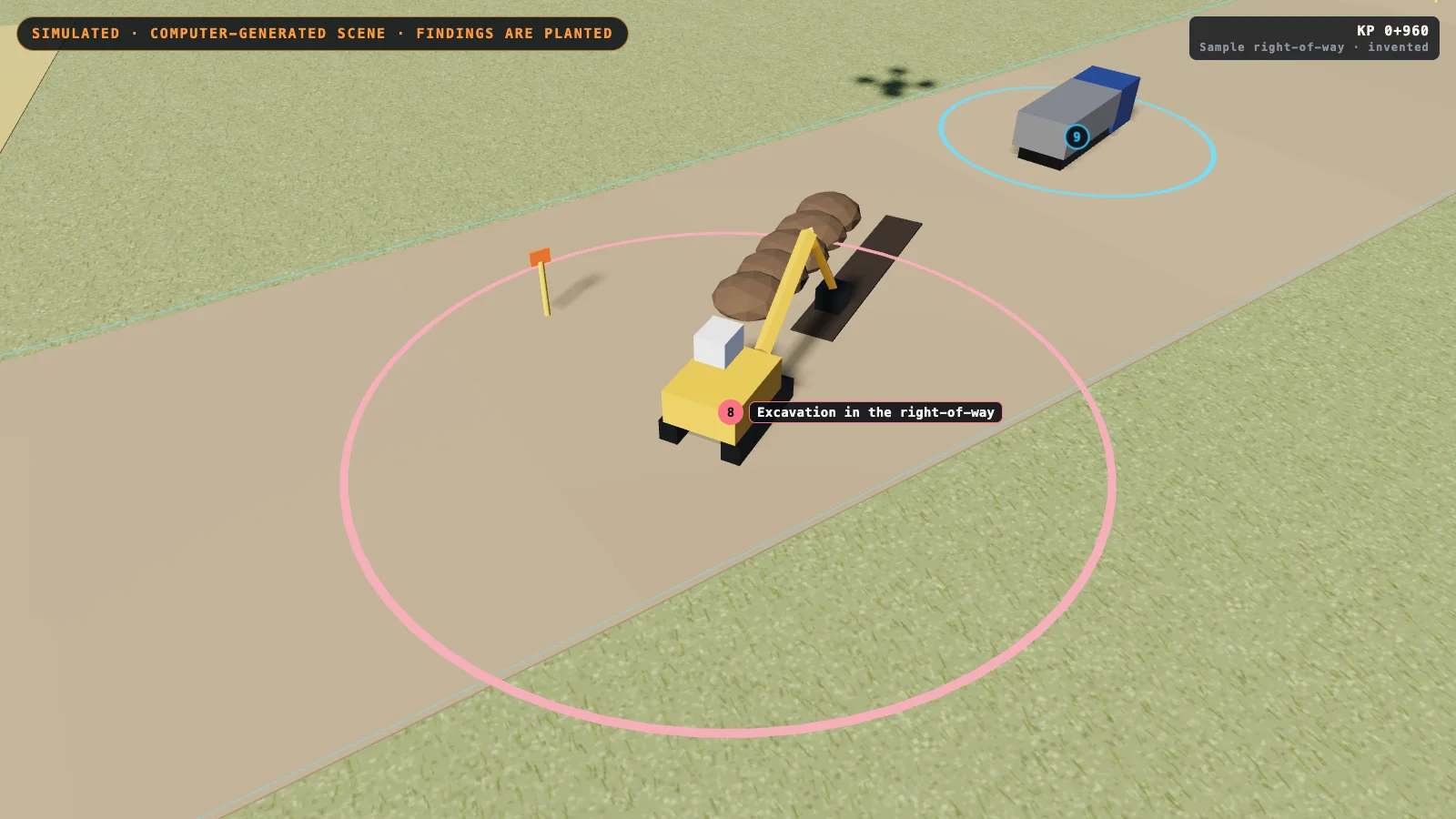
Simulated. The scene is computer-generated and the findings shown are the ones planted in it; no model produced them. You can open the simulated demo in a browser; the pictures here are stills from it, and each carries the tag “SIMULATED” inside the picture.
The demo is a simulated drone patrol along an invented pipeline right-of-way about 1.3 km long. The first 430 m of the line is above ground on supports, with one expansion loop; the line then goes below ground and is followed by marker posts every 60 m. The right-of-way is drawn as a cleared strip 20 m wide with its two edges outlined, and a stream and a village road cross it.
The demo plants ten findings of eight kinds along the line. In the strip around the line, the planted findings are a shed and a boundary wall built into it, an excavator with an open trench, a truck standing on it, and trees and scrub grown over the buried line. On the line itself, the planted findings are a damaged support, a missing marker post, and a washed-out stream crossing where the buried pipe lies in the open.
Three planted findings show only in the thermal view: a warm band on the above-ground pipe, a cold patch over the buried line and a warm patch over the buried line. A patch warmer or colder than its surroundings can have several causes and is a reason to look again on the ground. The demo gives its patches no cause, and there is no gas sensing of any kind in it.
Every finding is listed by chainage, the distance along the line from the start of the sample, and by which side of the line it is on. As the drone goes, the page counts the metres of line covered, the supports passed and the marker posts seen against the number expected.
The visitor can switch between a normal-colour view, a thermal view, and a split view with a divider that can be dragged. The visitor can clear any planted finding, or plant it again, and the scene and the list change with it; clearing the missing-marker finding puts the post back. The list turns into a one-screen patrol sheet that can be printed, with a suggested next step for each finding.
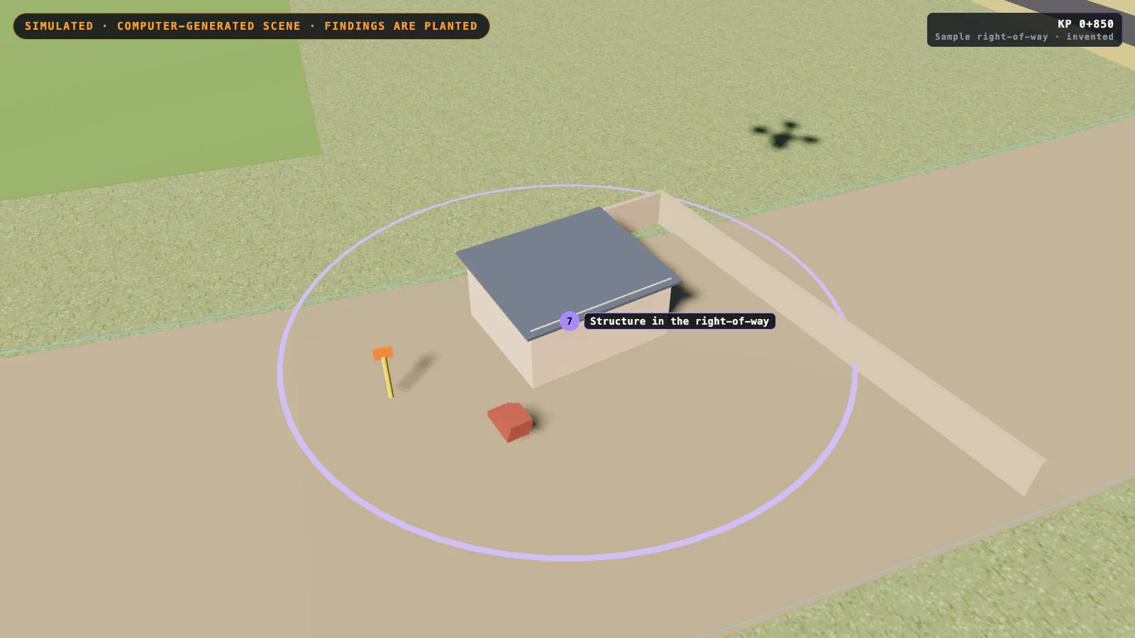
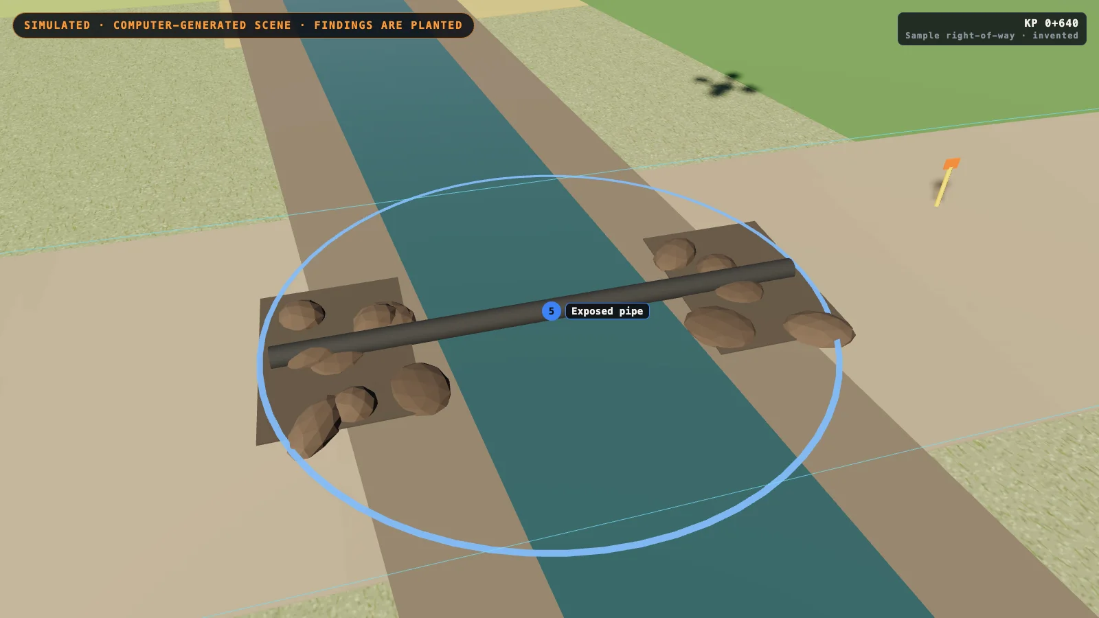
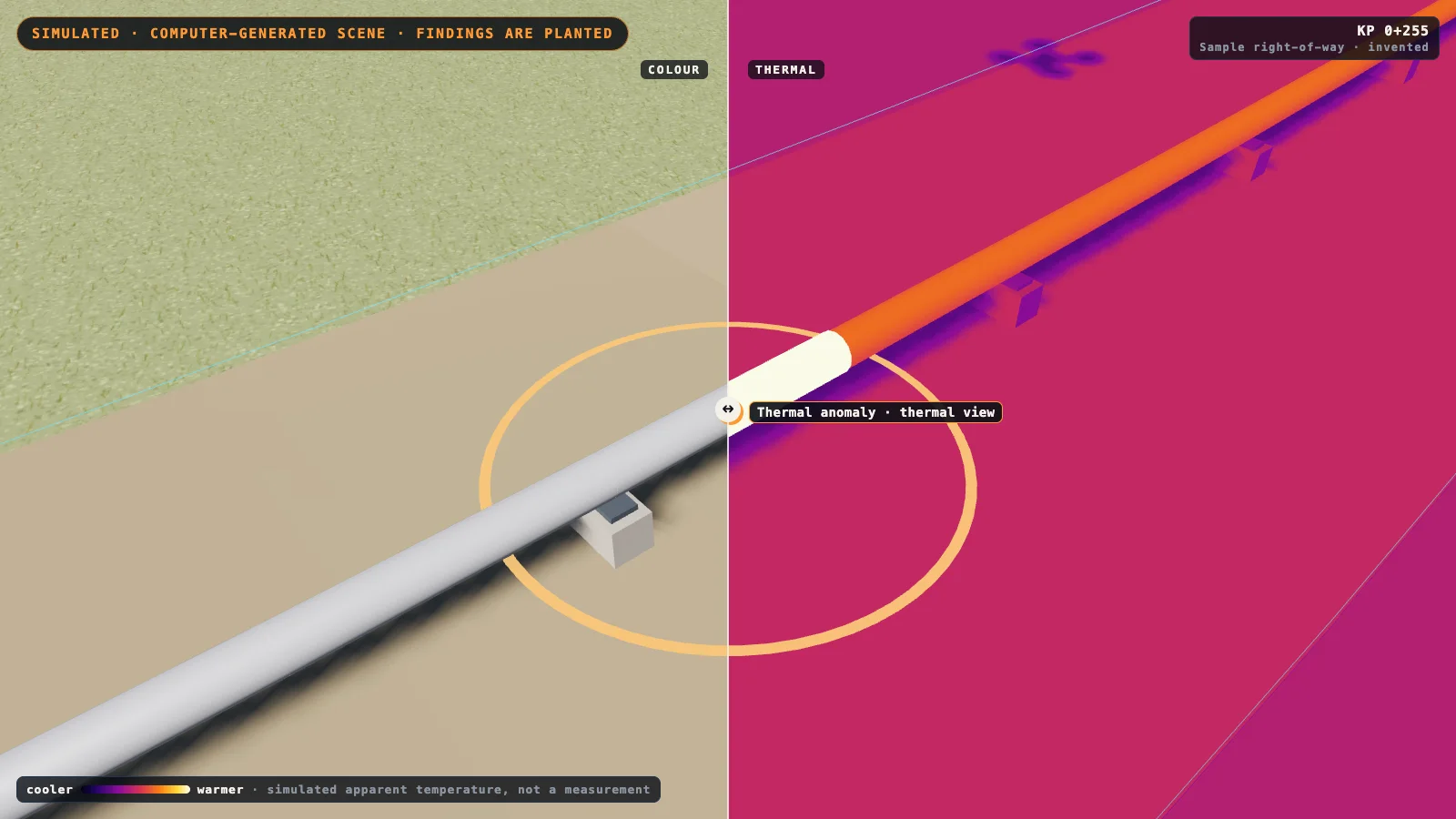
What is simulated in the demo, and where does it stop?
The list of findings is read from the scene itself, not from the picture: the page placed each one, so it knows its chainage. An inspection model has to do the reverse, which is why the demo shows the job and proves nothing about doing it.
The thermal view is a simple model, ambient temperature plus sunlight plus the warm and cold patches we planted, and it is not a measurement. The thermal view does not model soil moisture, wind, or the time of day.
The corridor is invented, flat and tidy; a real right-of-way has slopes, crops, standing water and long stretches where nothing is wrong. The planted findings are larger and clearer than many real ones, so that they read on a screen.
The demo covers about 1.3 km in a little over a minute; the flight is shown fast, and the demo says nothing about range, battery, permissions or flying beyond the operator's sight.
Nothing in the demo was tested on a real pipeline. The whole demo runs in the visitor's browser and makes no request to any other server.
What rules apply to the flight in India?
The inspection is a flight, and in India a flight by a drone falls under the Drone Rules, 2021. The Ministry of Civil Aviation's release on those rules describes an airspace map on its Digital Sky platform with green, yellow and red zones 4.
No permission is required to operate a drone in a green zone, which the release defines as the airspace up to 400 feet, or 120 metres, that is not marked red or yellow, and up to 200 feet between 8 and 12 kilometres from the perimeter of an operational airport 4. A pipeline's route is long and may pass through more than one kind of zone, so each stretch has to be checked on the map.
The same release says a type certificate is required when a drone is to be operated in India, with exemptions it lists; research bodies flying in a green zone on their own premises are among those it exempts from the type certificate and from the unique identification number 4.
That release is from 2021 and the rules have been amended since. Check the current rules and the map before any flight; this section is a description, not advice.
What this is not
It is not a trained model of ours. ShepHertz does not have a trained pipeline inspection model today: the demo on this page is computer-generated, the findings in it are the ones planted in the scene, and nothing has been run on a real pipeline.
It is not leak detection. Detecting a leak is the job of the operator's own systems, not of a camera. A flight can record what is on the surface, and a person decides what it means.
It is not what Drashta does today. Drashta is ShepHertz's machine-vision family. Today it finds aircraft and buildings in satellite imagery; inspecting solar plants, pipelines or power lines is not something it does yet.
It is not the patrol the rules require. Whether a drone flight counts towards an operator's required inspections is for the operator and its regulator; India's patrol clause does not name drones 5. This post describes the look, not compliance.
It comes with no figure. We give no accuracy, speed, coverage or saving figure, because we have none to give for this work.
It is not a customer story. No pipeline, operator or city gas company is described here, and none has used our software for this.
Frequently asked questions
How are pipelines inspected by drone?
A drone flies along the pipeline's right-of-way, the strip of land over the buried line, with a camera pointed at the ground. The pictures are read for construction, digging, machines, changes in the ground and anything else on the surface that was not there before.
What is a pipeline right-of-way?
It is the strip of land along a pipeline. Pipeline safety rules speak of inspecting the surface conditions on the right-of-way and adjacent to it 1.
How often does a pipeline right-of-way have to be inspected?
It depends on the country and the kind of line. In India, the standards for natural gas pipelines set a patrol once in 30 days for location classes 3 and 4 and once in every quarter for classes 1 and 2, with the whole route walked at least once a year 5. As one documented example from another country, United States rules require hazardous-liquid pipeline operators to inspect each right-of-way at least 26 times each calendar year, at intervals of no more than three weeks 1, and set longer intervals for gas transmission lines by the class of the location 2.
What does a drone look for along a pipeline?
What a patrol looks for. India's standards for natural gas pipelines name the surface conditions of the right-of-way, leakage, construction activity, encroachments and soil wash-outs 5; the United States gas rule names indications of leaks, construction activity and other factors affecting safety and operation 2. In pictures that means machinery, fresh digging, new structures and ground that has moved.
Can a drone detect a pipeline leak?
A camera on a drone can record signs on the surface, and patrol rules ask for indications of leaks to be observed 2. Detecting a leak is the job of the operator's own leak-detection systems, not of a camera.
Why is digging near a pipeline dangerous?
Because digging is how a buried line gets hit. The United States pipeline safety regulator states that excavation damage to gas and hazardous-liquid pipelines is a leading cause of life-threatening incidents, and that it can be prevented 3.
Does ShepHertz have a pipeline inspection model?
No. ShepHertz does not have a trained pipeline inspection model today: the demo on this page is computer-generated, the findings in it are the ones planted in the scene, and nothing has been run on a real pipeline.
Sources
Sources as read on 13 October 2026. The United States rules are cited as an example from another country. This is a description of what the texts say, not legal advice; the texts themselves govern.
- 1United States Code of Federal Regulations: 49 CFR 195.412, Inspection of rights-of-way and crossings under navigable waters, paragraph (a); text current as of 8 October 2026.
- 2United States Code of Federal Regulations: 49 CFR 192.705, Transmission lines: Patrolling; text current as of 8 October 2026.
- 3Pipeline and Hazardous Materials Safety Administration, United States Department of Transportation: National Pipeline Performance Measures.
- 4Press Information Bureau, Ministry of Civil Aviation, Government of India: Ministry of Civil Aviation notifies liberalised Drone Rules, 2021, 26 August 2021.
- 5Petroleum and Natural Gas Regulatory Board, India: Technical Standards and Specifications including Safety Standards for Natural Gas Pipelines Regulations, 2009, G.S.R. 808(E) of 11 November 2009, in the Board's consolidated text as amended up to 23 July 2025; Schedule 1E, Pipeline Maintenance, paragraphs 1 and 2.
Written by
AgentAnywhere Research
The team that builds the platform and the models
AgentAnywhere Research writes about the platform, the model families and the trust layer we build and run in India. Where a figure is ours, it says what it covers; where something is a demonstration, it says so.